
As my wife Sharron enjoys living in our family home in the UK (with frequent visits to see her mother in Canada) and I prefer to spend my time out of Britain, either in warmer climates or the mountains, we usually find ourselves spending between three and six months together and living separate lives for much of each year.

An early morning Zodiac cruise enabled us to view the giant icebergs emerging from the Ilulissat Ice Fjord.
However since first visiting Antarctica in 2012 (see here for an account of our initial impressions) we discovered we had a shared love of the Polar regions and we have made subsequent trips to Svalbard, a return visit to Antarctica via the Falkland Islands and South Georgia and last year we visited East Greenland.
For me the big attraction of the Polar Regions is the spectacular landscapes with features that one normally associate with high mountain scenery in the Alps and Himalaya. Indeed, because of the latitude, jagged peaks, knife edged arêtes, snow filled cirques, hanging valleys, moraines and giant glaciers disgorging into the sea to form icebergs are all ‘brought down’ to sea level and some of the most spectacular ion the planet is in your face.

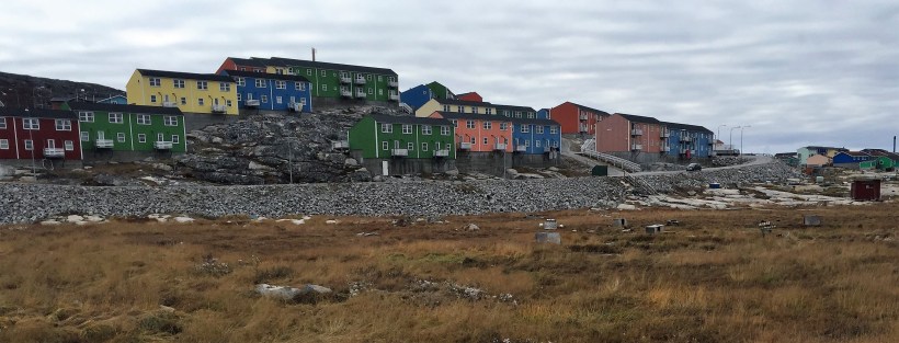
Ilulissat is Greenland’s third biggest town with a population of 4500 and fishing and tourism form the basis of the economy.
And it is all in front of you without any effort or days of hiking required to penetrate into the high mountains!
When you combine this with the abundant wildlife that Sharron loves it is truly an unbeatable combination and topped off by the incredibly shaped icebergs often right in front of you.
We were so impressed with the spectacular scenery of East Greenland last year that we decided to return this year on a small expedition cruise that visited southern Greenland and finished up at Baffin Island in Arctic Canada. We then decided if we stayed on the boat and joined the subsequent Expedition starting on Baffin Island we could explore some more northern parts of Baffin Island before visiting the western coast of Greenland!
As we planned to visit West Greenland in the future it made more sense to do two back to back expeditions as there was a significant saving of expenditure by eliminating the two additional transfers and international flights as well as the aggravation of Sharron and I both trying to combine our calendars to be in the same place at the same time.

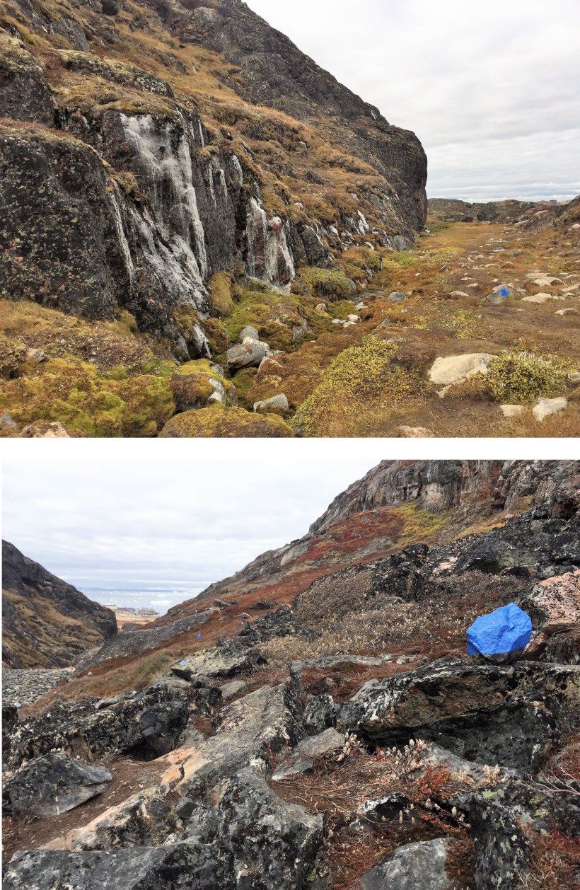
The Blue trail could not be more clearly signposted.
So in late August after a couple of days exploring the dramatic and remote Westfjord area of Iceland we joined 89 other passengers in Reykjavik to fly to Iceland’s charming second city of Akureyri (population 18,000) and join our boat, the Polish built ‘Ocean Atlantic’ to set sail for Greenland.
The first expedition went well (you can see a selection of images here) and an early highlight was discovering pod of over 200 whales surrounding our vessel with spouts of water and the backs of whales being part of the view in almost every direction. We explored fjords in South East and Southern Greenland before visiting Greenland’s quaint capital of Nuuk but then a strong storm system prevented our crossing the Davis Strait to Baffin Island as planned so we had an additional two days in protected waters in fjords to the north of Nuuk where we had the opportunity to do two hikes and visit a local Inuit Festival. In fact we were the only passengers to ‘benefit’ from this modification to our plans as we gained two new destinations in Greenland and ‘lost’ the only two days that were duplicated on the provisional itineraries for both expeditions.

The Boardwalk provides easy access to the Ilulissat Ice Fjord for those tourists prepared to make a 1.5 mile return walk and protects the habitat from damage.
So it was that on September 13 we arrived at Iqaluit, the capital of Canada’s Nunavut Territory and said goodbye to 89 passengers and welcomed 103 new faces, so out came my trusty notebook, jotting down new names and home towns of fellow passengers as we met them. There were 19 nationalities represented by the 105 passengers, American’s by far the largest this time followed by about 17 Canadians and 15 Brits.
We sailed north along the coastline of Baffin Island sighting Polar Bears and Whales and were the first ship this year to visit the small settlement of Pangnirtung, renowned as a centre for Inuit Art and in particular for its paintings, prints and fabrics. However the highlight before recrossing the Davis St to Greenland was sailing up Sam Ford Fjord into Force 10 katabatic winds that were so strong one could defy gravity and lean into the winds at a 60 degree angle!
After exploring parts of the west Greenland coast our penultimate day in Greenland was to be spent in and around Ilulissat, Greenlands third biggest town with a population of 4,500! It is famous for being home to almost as many sled dogs as people!

An easy 1.3km walk brings walkers to the magnificent Ilulissat Ice Fjord. Unusually there were two boats and a total of 250 passengers visiting Ilulissat on the same day and perhaps 150 of them made the walk!
Ilulissat’s main attraction is its location near the mouth of the Ilulissat Ice Fjord and our first option after a 0545 wake up call was to join a short one hour Zodiac cruise amongst the icebergs. I am not in any shape or form a morning person but had learnt to adapt to the 0730 wake up calls and breakfasts from 0730 to 0830 (I am used to going to bed at 0430 and getting up at 0930 but on the boat had adapted to 0230 – 0730) but when I looked out I could see fairly low lying cloud and initially decided that meant an extra couple of hours in bed. And then I decided as I was up I might as well get dressed, put on my wet weather gear (mandatory for Zodiacs) go down to the Mud Room to put on my Muck Boots and Life Jacket and go – after all this was the last time to go up close to Icebergs etc for at least another year.

The Ilulissat Ice Fjord provides no shortage of photo opportunities.
I had passed on the last early morning sunrise Zodiac cruise and this time it was Sharron opted to stay in bed.
Before every Zodiac the attentive Expedition crew check your gear and two of the Ships Crew are at the end of the gangway to help you down into the Zodiac, immediately shuffling down to your appointed place and there were 8 of us per Zodiac. All the Zodiacs were launched and I think about 8 Zodiacs took around 64 of the passengers off, broadly staying in pairs.
Parts of the sea were lightly frozen so we could not build up much speed as we navigated headed towards the wall of ice in front of us, taking care to avoid the larger blocks of ice. And no speed meant it was not too cold as I had a T Shirt and fleece beneath my Heavy Duty Waterproof Parka (with an attached fleece lining) provided by Quark Expeditions to every passenger on every expedition. I am now the owner of 8 of these excellent pieces of kit and keep one in Somerset, London, Switzerland, Canada and Thailand (minus the fleece lining) so I guess one of our kids will get the 6th as a Christmas gift this year!
Meanwhile as this tale will tell it is very easy to pick out a fellow Quark passenger – they are the ones wearing the bright Yellow Arctic Parkas!

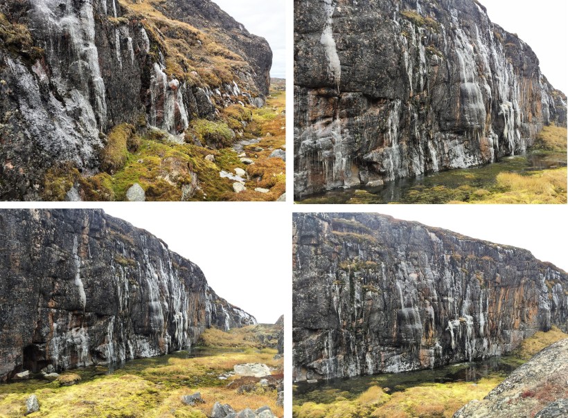
The Ilulissat Ice Fjord is packed solid with icebergs that can take decades to reach the open seas.
Our driver was the Botanist Dave, born as a Geordie in the North East of England, grew up in Wales and living in Arctic Canada for the past 20 years. He also sets a brutal pace when leading hiking groups which is testified by the fact I was the only person to sign up for all three of the ‘Charging’ Hikes that he had lead on the previous expedition!
There was an Expedition Crew of 15 plus 5 Trainees to look after the 105 Passengers including a Doctor, several marine biologists with different specialities, two Ornithologists, a historian, geologist, glaciologist, botanist and all were required to be competent Zodiac drivers and at least half were qualified to carry a rifle which was mandatory when we were ashore in Polar Bear Country. The Nationalities of our expedition crew included Americans, Canadians, Chinese, Brits as well as a Russian, Australian and South African. The Boat has a crew of 50 plus another 10 Catering and Hotel staff.
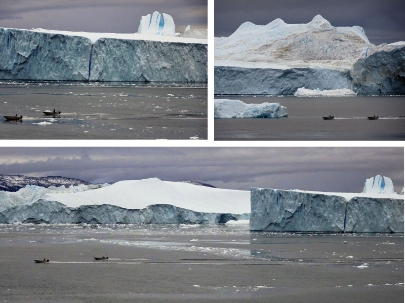
I was soon pleased I had decided to come as we were approaching some of the largest Icebergs I had ever seen, one with at least a 30 metre cliff face that extended at least 300 metres long and don’t forget there is always much more of the iceberg out of sight under the water!
All of these icebergs were disgorged into the ocean from the Ilulissat Ice Fjord which in turn was fed by the Jakobshavn Glacier 40km/25 miles inland. The glacier is the fastest flowing in the northern hemisphere disgorging up to 25 metres of ice daily into the fjord which incredibly results in up to 20 billion tons of icebergs entering into the ocean each year. The Icefjord is a UNESCO World Heritage Site and it is believed to be the source of the Iceberg that sank the Titanic.

The Icebergs finally reach the open seas.
There was iceberg after iceberg all on top of each other and some of them had peaks that you would assume were mountains on the shore until you looked closely and realised they were part of these icebergs, surely amongst the biggest if not the biggest I had ever seen. We kept our distance to 300 metres or more because all these icebergs in time would crack and calve, fragmenting into smaller pieces.
If one of the icebergs started calving there were three things to worry about because falling or splintering ice would easily kill people ( and has done in the Arctic), the tsunami type wave that would result could capsize our Zodiac and thirdly when part of the iceberg calves off it forms a new structure and the new iceberg will have to find a new centre of equilibrium. This will often involve the newly released ice block to rise from under the water and the mayhem near the glacier can only be likened to a war zone!

A stark contrast between rock and ice on one of the worlds most spectacular day hikes.
We were once fortunate enough to see and film a giant calving in Wilhelmina Bay, part of the Antarctic Peninsular and the most dramatic aspect by far was to watch this giant structure arise out of the sea for probably the height of a 5-storey building before rolling over and finding a balance to match its new form. It was the most dramatic manifestation of the earth’s physical powers that I have ever seen.
After an hour or so of admiring the icebergs it was time to return to the boat for our buffet breakfast capably supervised by our Hungarian Maitre D, Gabor, a dead ringer for Ali G both in mannerisms and appearance and with a new tie to entertain us on a daily basis!
And then after breakfast a series of shuttle Zodiacs took us to shore.
I had already seen from the Zodiac Cruise and our off shore anchorage that Ilulissat was a typical Greenlandic town with neat and brightly coloured houses close to shore which was quite a contrast to the two Canadian settlements we had visited on Baffin Island. In Greenland the houses and settlements were neater and tidier, there were fewer unkempt and abandoned buildings and more of a sense of community.

The Blue Trail is clearly marked by painted blue boulders!
Historically Canada has a poor record in its misguided treatment of its native and indigenous peoples which it has perhaps tried to rectify in recent decades by throwing money at these communities but possibly without a proper infrastructure, management and monitoring structures in place. I am not remotely qualified to draw conclusions from a few brief visits but undeniably the Greenlandic settlements reflect a greater pride and sense of community and wellbeing than those we visited in Arctic Canada.
Once we were ashore I quickly dumped by heavy duty Yellow Parka and lifejacket at a secure point on the jetty and got in the shuttle bus to take us to the trailhead as our first objective was to walk to a viewpoint overlooking the ice fjord. And however cold it was the regulation parkas were far too heavy and hot for serious walking and I had brought a lightweight water repellent wind jacket that I used on all the hikes..

The Blue Trail provides no shortage of magnificent views over the Ilulissat Ice Fjord.
However no sooner had we pulled away than I realised I had left my compact Sony 28 -750mm zoom rangefinder camera in my jacket pocket but did not think it was fair to everyone else to ask them to wait whilst I retrieved my camera.
No sweat I could use my iPhone.
Oh No I couldn’t – I had left it charging on the boat!
Sharron and I were planning to do different walks and I eventually managed to persuade her to lend me her fully charged iPhone as she had also brought her camera.
There were three trails from the trailhead at the Old Town Heliport and to make things easier for visitors these were described as the Yellow Trail, a circular trail to the coast from the main trailhead of around 2.7km and estimated at 1.5 to 2 hours in duration, the Red Trail a 1km in and 1km back out to a point on the Blue Trail and the more challenging Blue Trail that was 6.9km and estimated at 4-5 hours as it involved a little scrambling over some boulders. I had also noticed that the end trailhead for the Blue Trail was at least 2km from the town centre so I was probably looking at a hike of around 9km/6 miles as the Blue Trail was the only game in town for me as hiking and mountain walking is the passion of my life.

Some of the icebergs in the Ilulissat Ice Fjord are the size of mountains!
Sharron was planning to do the first 2km of the Blue Trail and then cut off on the Red Trail to return to the trail head.
I had to chuckle as the naming of the routes as Yellow. Red and Blue was almost as (un) imaginative as the four boat trips offered from El Nido in the Philippines – Tours A,B,C and D. However as I was to see, there was a very useful method in the Greenlander’s madness who came up with such the designations.
The walk started off in a rather incongruous fashion as a Boardwalk had been built for the first kilometre from the trailhead to the fjord so there were at least 60 Yellow Parka Clad passengers from our Expedition Boat and by chance the Ocean Atlantic’s Sister ship was also visiting Ilulissat the same day! So must of that ship’s passengers were also coming and going along the first kilometre of the Boardwalk and reflecting various stages of fitness and not so fit.
I had zero problems with the Boardwalk because some of the people would have been struggling on the soft Tundra and as Ilulissat was the most northerly settlement on the West Greenland coast that was ice free year round it was one of the most visited destinations in Greenland so it obviously made sense to protect the vegetation from the high volume footfall.

We can all pretend to be Ansel Adams amidst such spectacular scenery.
After about 10 minutes more and more ice came into view in front of us as the land gently descended to the fjord shore, in a manner not dissimilar to the Himalaya rising above the dry and dusty Tibetan Plateau. However one could not see much water in the fjord as it was packed solid with icebergs everywhere and to the right we could see the icebergs out in the ocean and I recognised many features I had seen earlier in the morning from the Zodiac.
There were a couple of outstanding vantage points on the rocky bluffs overlooking the ice fjord where the bulk of the 150 hikers arriving and departing from the two boats were congregating and admiring the view with hundreds of fantastically shaped icebergs forming no shortage of spectacular photo opportunities.
Almost all of the people at this point were turning around and going back to the trailhead with the intention of taking the shuttle back into town where the attractions included a Museum, supermarkets and souvenir shops and I was aware that as were one of the last Zodiacs from Ship to Shore I could not afford to dawdle as we had to be back at the jetty by 4pm and although I did not suspect it would take me 4 hours which was what was posted I had no idea what the condition of the trail was like and how long it would take me.

Sharron accompanied me along the first part of the Blue Trail.
So at 1130am as Sharron as I headed west along the Blue Trail I was conscious we were the only ones heading in that direction and the reason for the naming of the trails became very clear.

The Blue Trail is impeccably marked and it is impossible to get lost.
We were told the trails were clearly marked with Blue flashings every 20 metres and of course it is not unusual usual for trails to be marked. In the Alps all trails are signposted and in addition there can be Yellow (easier) or Red on White or Blue (more difficult) flashings on rocks and trees in areas where it could be easy to lose the route. And indeed this could be every 70 – 100 metres where the trail is not obvious but the Blue Trail was marked every 20 metres and not just with a few neat brushstrokes of weather resistant Blue paint. Entire boulders were painted blue and there were cairns made of blue rocks and there were blue markings literally about every 20 -30 metres.
It was truly impossible to get lost and done in a sensitive and aesthetic manner and very sensible because it was quite likely that many of the people undertaking these walks did not have a lot of hiking experience!
And all the time as we walked over the clifftops to our right we had ‘Iceberg Alley’ with hundreds of icebergs jammed solidly against each other.

Follow the Blue markers to stay on the Blue Trail!
The Jakobshavn glacier which feeds the fjord is the fastest moving glacier in Greenland discharging up to 30 metres of ice into the fjord every day and this ice, which can be tens of thousands of years old, is sometimes up to a kilometre in length and will often get stuck for years in the shallower sections of the fjord.
It will often only be shifted when it is broken up by the pressure and weight of all the ice accumulating behind it as the glacier relentlessly pours more and more ice into the fjord every day. Once the ice has calved off into the fjord it can take many years to reach the ocean and this one glacier is responsible for discharging 10% of all the ice from the entire Greenland Icecap. When one takes almost two hours to fly over Greenland and one looks look down on thousands of square miles of ice that is some statistic!
It seemed every square metre of the fjord beside us was jam packed with icebergs in every which direction and I thought it was no wonder this area was a UNESCO World Heritage Site. I have walked on countless glaciers and sometimes for days on end but this was quite a spectacular iceberg traffic jam quite unlike anything I had seen before!

A last look back at the magnificent icebergs before the Blue Trail turns inwards.
As we walked along we met the Swiss Girls Sonia and Isabel (from Bern and Davos respectively) from our boat and they were doing the same walk as Sharron but in reverse. They had been participants in both the ‘Charger’ Hikes on the trip to date but had opted not to do the Blue Trail. A few minutes we crossed Ashok, a friendly American of Indian origin who was following the same route as the Swiss pair and then after 45 minutes we came to the Red Trail Junction where Sharron was going to take a left.
At this point I could see the trail snaking up and down following the fjord for at least another two if not three kilometres and I was beginning to think I might not have allowed myself enough time as I knew the trail was due to turn inland and it still seemed to be going straight ahead for some while.
But wait a minute. I could see two Yellow jacketed hikers ahead on the climb up to the next bluff but they did not seem to be on what I assumed was the trail.

Heading inland and looking back at the Ilulissat Ice Fjord.
Anyway at 1215 I said farewell to Sharron, reassured that at least someone knew where I was and headed on at a brisk pace following the blue markings and soon realised the trail I saw lower down near the fjord shore was a local’s trail up the fjord presumably for hunting and not the Blue trail. And it was not long before I caught up the Yellow jackets I had sighted which were the Dutch couple Peter and Matilde from Leiden in, also off our boat and who had also been on both of the ‘charger’ hikes to date.
They were strong hikers and having a leisurely lunch of packed sandwiches that we had all brought from the boat but had decided to turn around at that point as the path appeared to cross a small boulder field. They had not seen anyone ahead but I decided to keep going and after maybe 30 or 40 metres of careful foot placing as I rockhopped (and clearly marked with blue signs!) I was back on the fairly well groomed trail.
I had done 5 previous hikes since leaving Iceland and all had been characterised by being distinctly bushwhacking, ie no marked trail and walking through either knee height willow or peat like marsh and both can get tiring so it was nice to follow a marked trail.
And it looked like there was a bonus in that the trail which continued ahead was not the Blue Trail and it looked as if my trail started its way inland up a shallow valley.
Walking on the tundra has a myriad of delights with many different miniature plants and flowers, lichens and mosses and there were shallow pools and little brooks all around me. I had stopped to take photos of some frozen pools and then a little stream with a miniature frozen waterfall as the water poured into a little pool when I saw another Yellow jacket approaching.

This magnificent lake on the Blue Trail would not look out of place in the Scottish Highlands!
This time it was Steve, an Amazon employee from Seattle who had also been one of the ‘charger’ Hiking group – he had gone about 80% of the way to the end of the blue trail but when overlooking Ilulissat he had decided to retrace his steps to get back to the trailhead where he had started and do the Yellow trail!
It seems I was meeting just about all the stronger hikers off the boat (there were only 8 of us who had participated in the ‘Charging ‘ hikes) on this hike but no one was doing the full hike but from what Steve told me I was going to have plenty of time. Steve said he had seen a woman hiking in front of him but was not sure if she was off our boat – I was pretty sure she was not as I had already met the three stronger female hikers off the boat and so it proved.
With the stream rushing towards me on my right, I made my way up the gentle valley heading inland with the ice choked fjord behind me and soon came to a Lake that would not have looked out of place in the Scottish Highlands.

Lake and Mountains form quite a contrast to the Ice fjord I had left behind.
With a last look at the magnificent ice fjord I followed the trail up and over the rocks to the left of the Lake with hardly a moment when there was not a blue marking in my view ahead. I was already thinking this was a walk of outstanding variety with some world class scenery.
And little did I know that one of the most impressive features of the day still lay ahead as the path suddenly dropped and then took a sharp left and headed up a narrow ravine with a small frozen waterfall attached to the ravine wall on my right and then another.
The trail continued up perhaps 50m in ascent to a narrow col between higher rocks on either side. This was the first time I could recollect following a ravine to cross a ridge and I had clearly reached the point where Steve had turned as I could now see the town of Ilulissat below me.

A narrow canyon leads to the high point of the Blue Trail.
I climbed up the rocks on my right to take some photos and was tempted to stop for lunch except I had a wet T shirt and Gillet from all the effort I had put in. (I only have to look at a hill to sweat!). Whilst it was not cold once I sat a cool breeze would be quite uncomfortable so I kept going and once I crossed the Col and started to descend there was another pleasant surprise because the trail followed a narrow descending canyon. There were two areas of rock fall where some boulder hopping was necessary but nothing more challenging than some of the ‘charger’ hikes we had taken in recent weeks.

Decorative ice on the canyon walls.
And there were many parts of the canyon that were like a wall of ice as waterfalls and streams had frozen to form a white curtain cladding the canyon walls. And in other places collections of long frozen icicles which resembled organ pipes were gracefully frozen to the canyon walls.
At this point I realised that the Blue Trail was truly a world class day hike that would not be out of place on every serious walker’s checklist if it were found in a more accessible location. With one of the world’s great concentration of spectacular icebergs as a constant companion for the first half of the hike and then a beautiful stream, a dramatic brooding lake with rocky peaks towering above, a ravine and a magnificent miniature Grand Canyon , there was no doubt the Blue Trail possesses an almost unrivalled variety of scenery for a day hike. And in addition tundra vegetation and frozen canyon sides provided an additional and aesthetically rewarding bonus!

Not dissimilar to Moorland walking in Britain with tundra underfoot.
As I had descended the Canyon towards Ilulissat I could not help but here the barking of dogs, many dogs, in fact 1,500 dogs who were kept in the area to the west of town that I had to pass through. I wondered if these were barks of delight as the dogs heard lunch approaching!
Greenlanders use dogs for pulling their sleds for both transportation and hunting and it is stressed to visitors to not touch or pat dogs unless invited to by their owners. If a dog bites you they will be put down and quite often the rest of the pack as well which could have a severe impact on the owner’s income.

Looking down over Ilulissat Town.
As I wandered through the area of giant kennels of all shapes and sizes I realised that most of the dogs were chained up, albeit on long leashes and fairly docile, in fact many were sleeping. And good to its name, footprints in blue depicted the way the Blue Trail meandered through the dog kennel area!
I reached the trail head at 1415, two hours after I left Sharron so the whole route had taken me three and a quarter hours to walk excluding the first long stop overlooking the fjord.
However I still had another two kilometers to walk to get to the centre of town and I walked past some new low level apartment blocks. I also noted that many of the houses shared stepped pedestrian access boardwalks from the road to all the houses.

A spectacular canyon leading to Ilulissat town formed the final part of the Blue Trail.
Like other towns in Greenland there always seems to be plenty of people walking home along the road as I made way to the city centre. I found many passengers from our boat in the centre but no sign of Sharron and as I had no cash nor reason to stay in town, I took the shuttle to the jetty, retrieved my yellow parka with camera safe in the pocket, took some photos of fishing boats out of the water and got the Zodiac back to the boat for a warm bath in our cabin. I was fortunate to do so just as the two skippers of the sister ships were placing the two ships nose to nose for a rare photo-op.
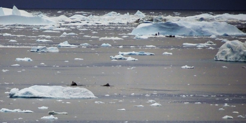
Late afternoon before leaving the area the Captain took the boat close to the iceberg area so people could have a final look at the magnificent and massive icebergs when Sharron and some others on deck saw some local seal hunters land on one of the smaller icebergs. Try as I could to follow Sharron’s instructions I was unable to see the hunters.
However I did spot two hump back whales swimming in tandem and when I looked at the image I captured through the zoom lens of my rangefinder lo and behold I discovered I had inadvertently also captured the seal hunters on an ice flow in the background!
Call it photographers luck but if one takes enough images one earns those breaks and that was not a bad way to end a day that featured one of the best (and relatively easy) day hikes that I have ever taken.
I have hiked to Everest on several occasions, to Machu Picchu via the Inca Trail and to the summit of Kilimanjaro as well as several of the well-known multi day hikes in the Alps but if you can find a way to get to Greenland’s capital Nuuk and then take a coastal vessel or internal flight to Ilulissat, you will be welcomed to a town that can offer you a variety of activities and at least one hike that is genuinely of a world class standard.
After all it is not every day that you can walk besides the world’s greatest collection of icebergs!
Please Note: If you enjoyed this article you might be interested in reading ‘Gravedigging in Greenland’ which you can find here and also view the images in the gallery of photos taken in Scorsbysund which you will find here.
© Michael Bromfield
Additional Images
Blue markings lead hikers back to Ilulissat.
Ice clad canyon walls

Ice Patterns

The walk concludes with a walk through the Ilulissat Husky Dog Kennel area, home for hundreds of dogs.
After the end of the trail there was an additional 2km to the centre of Ilulissat which passed through residential housing areas.

At the end of the day the captain lined up the Ocean Atlantic with its sister ship, coincidentally also visiting Ilulissat.
Fishermen returning to Ilulissat with giant icebergs behind.
Whales and Seal Hunters at the end of the day.

January 19, 2018 at 6:43 PM
Hi Michael: I enjoyed reading your Blog Post on Ilulissat. Brought back wonderful memories of that spectacular day. As it turned out, I was with the Dutch couple on the Red trail until it met the Blue one. Then I turned right and they went left. That is when I mer you and Sharron. I specially enjoyed the description of the part of the Blue trail that I did not walk on. Great!! Regards Ashok Ashok B. Boghani+1 (617) 650-3301 Acton, MAMy blog: http://ashokbo.blogspot.com My photos: https://www.flickr.com/photos/ashokbo/
Pingback: 45 – The Kibungan Circuit (or at least part of it!) – The Cordillera Mountains, Luzon, The Philippines October 24 – 29 2017 | Notes from a Nomad
January 2, 2026 at 8:52 AM
The descriptions of polar landscapes are captivating.